
© J.H.Mathieson

The Census to Parish link Utility
(CPLU)*
The CPLU can be used to locate District Electoral Divisions and identify the parish in which each DED is located.What’s Included in the CPLU?
• 9 county maps with accurate parish boundaries and related map keys. • 9 parish/DED maps and boundaries with related map keys. • The maps and tables are compiled in a a desktop module.The 1901 Census
The 1901 census is the most comprehensive set of records available for 19th century Ulster researchers. However there is a problem. The 1901 Census uses the District Electoral Division (DED’s) boundary while most 19th century records use Civil Parish boundaries. The problem is further complicated by by several additional factors. • Maps of DED’s are not readily available. • While some DED’s can be recognized by their names, the the vast majority use nomenclature unfamiliar to all but the most seasoned Ulster researcher. Therefore it is usually not possible to correlate the DED with the Parish in which it is found.The CPLU
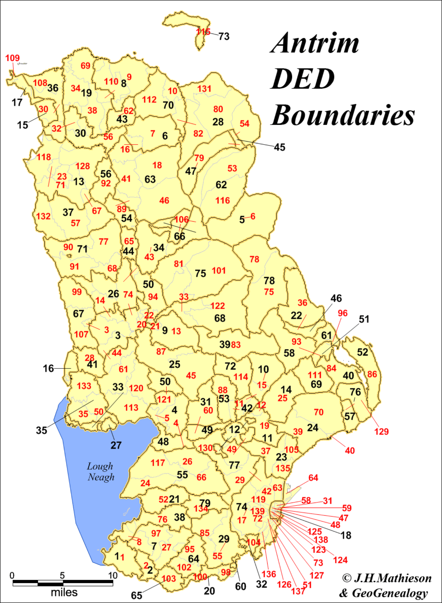
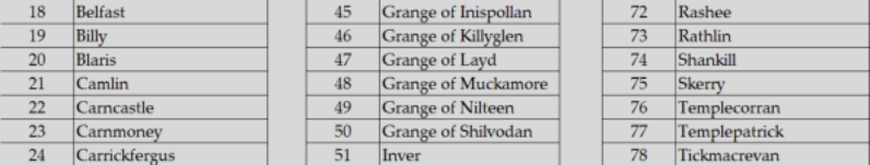
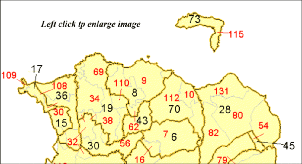
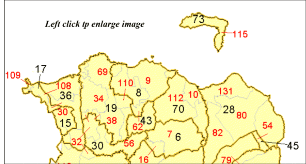
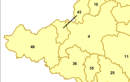
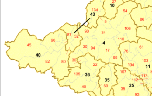
The CPLU solves this issue and maps each DED in it’s corresponding Civil Parish. . In County Antrim for example there are 79 parishes and 179 DED’s. On the maps parish boundaries are numbered in black and the DED boundaries are numbered in red. • The names of DED’s and Civil Parishes can be identified from the Civil Parish or DED keys for each county. Using the Antrim parish key we learn that Civil Parish # 19 is Billy. Within parish ##19 we find three DED’s, 34, (Bushmills) 38, (Carnmoon) and 69, (Dunseverick). • As DED’s are more numerous than Civil Parishes, generally you will find 2 or 3 DED’s in each Civil Parish. The situation is complicated by the fact that portions of a DED may be found in adjacent parishes. In fact portions of a DED may be found in several adjacent parishes! • Referencing Northern Antrim, portions of DED number 110 are found both in Parishes 8 and 19 while DED 32, (Benvardin) is split between Parishes 36, (Dunluce) and 30, (Derrykeighan). The number of a DED is assigned to the Parish in which it is found and a red line links the location of smaller portions of a DED found in adjacent Parish’s.Using the CPLU to Locate an Ancestor
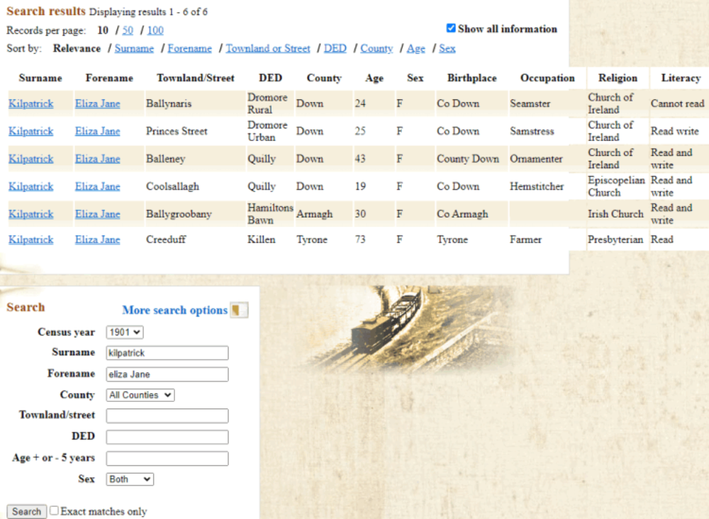
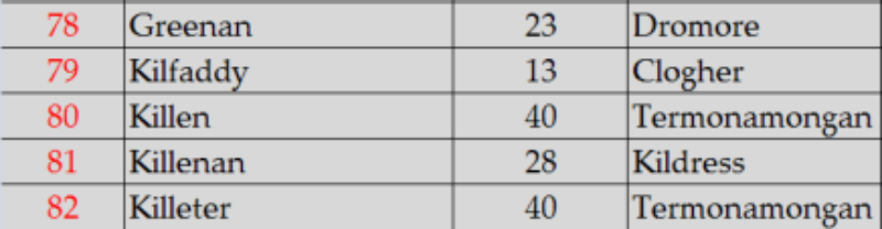
You are looking for an ancestor Eliza Jane Kilpatrick, the sister of your Great Grandfather who emigrated from Ulster to America immediately following the Great Famine. A family Bible tells you he had a sister born in 1831. A search for Eliza Jane Kilpatrick returns the following individuals. Of those listed, Eliza Jane found in Killeen County Tyrone might be a possibility. She is 73 years old which would be close to her age listed in the Bible. Consulting the DED list for County Tyrone we find that DED Killen is #80, and is found in Parish # 40, Termonamongan. We then consult the parish map for Tyrone to locate parish Parish # 40, Termonamongan which is found in the far west of County Tyrone. Looking at the DED map we find Killen (#80) in the South east corner of Termonamongan with a small section in the Parish of Urney,(#43).Locating a District Electoral Division
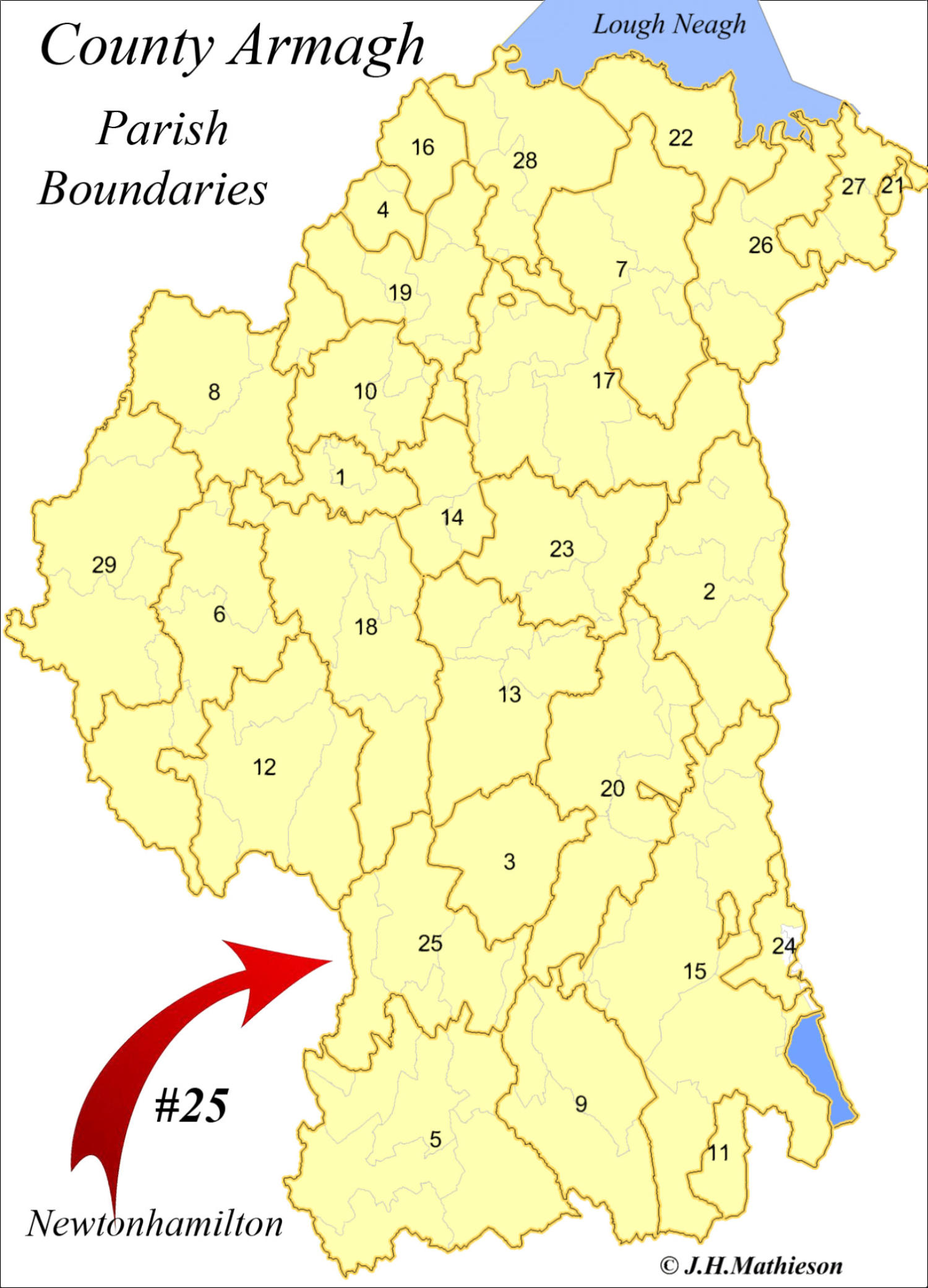
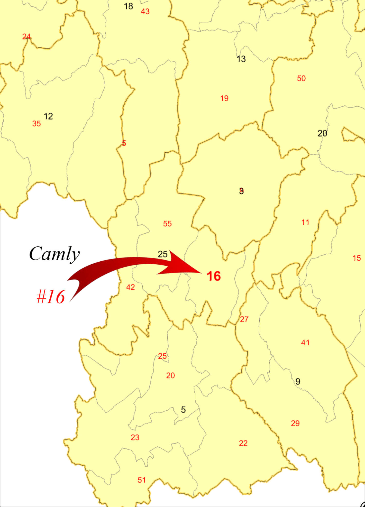
If you want to simply locate a DED and your know the County, select the county from the county menu and search the DED key. Take for example Camly, a DED located in County Down. Referencing the alphabetical DED key for County Down we find Camly is DED #15 in Newtonhamilton Parish #25. If you want to simply locate a DED and your know the County, select the county from the county menu and search the DED key. Take for example Camly, a DED located in County Down. Referencing the alphabetical DED key for County Down we find Camly is DED #15 in Newtonhamilton Parish #25. If you don’t know the County, search the master CPLU Excel file* for a DED. The master CPLU key provides the Civil parish ##, the DED ## and County in which a DED if found. Then reference the parish and DED maps. *(provided with the CPLU program) The CPLU project includes a master Excel file listing all the DED’s in Ulster, their DED code ##’s, the Parish name and the Parish ##. View the CPLU*Note: Your personal surname census data, the Griffith
Valuation and the1901 census can be bundled as part of a
“Surname Atlas”.