Click to enlarge

© J.H.Mathieson


Place Names and Surnames of the Ancient Woodlands
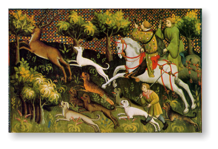
The Woodlands of England have been idealized by
landscape artists and venerated in prose and poetry.
Throughout England’s history they have been a source of
immeasurable wealth. Woodlands have provided fuel and
building materials for home and industry, masts for tall
ships, and recreation for the rich and famous.
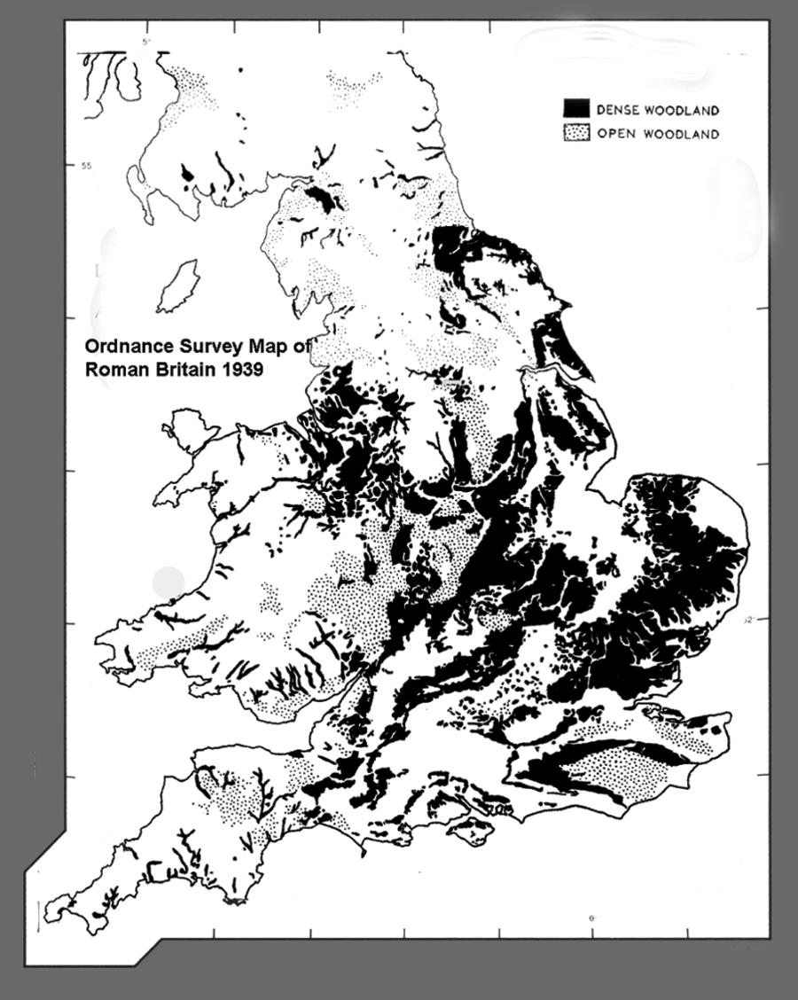
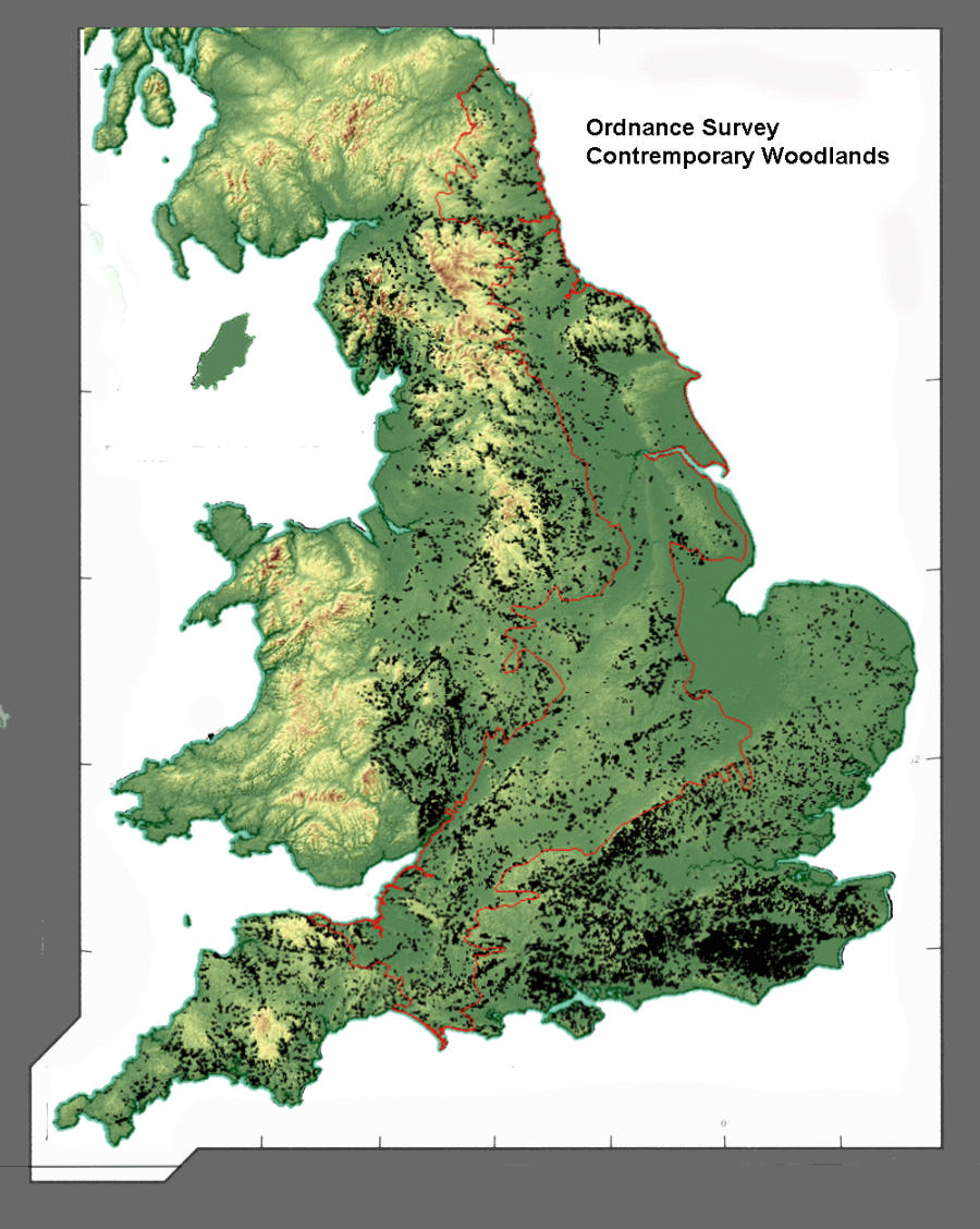
Over the passage of time the areal extent of the Woodlands
would be diminished and eventually the pressures of
insatiable demand would necessitate that England look beyond its borders for its needs. The process of
deforestation would be transformative. From the time of the early Britons, through the Anglo Saxon era
and the age of the Normans, the landscape would be
redefined and in most areas farming would become
ascendant. In the 12th and 13th century as population
expanded and as forests were cleared, the memory of
these woodlands would be memorialised in the
surnames of those who toiled the soil.
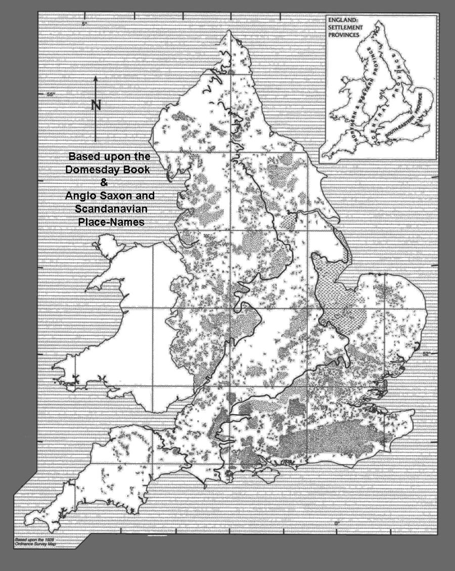
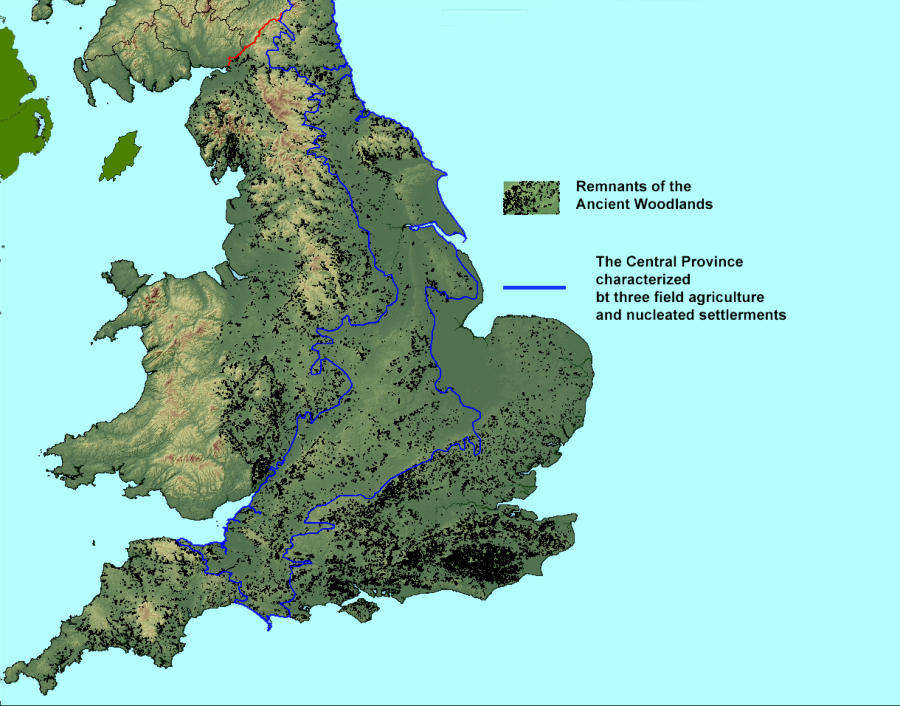
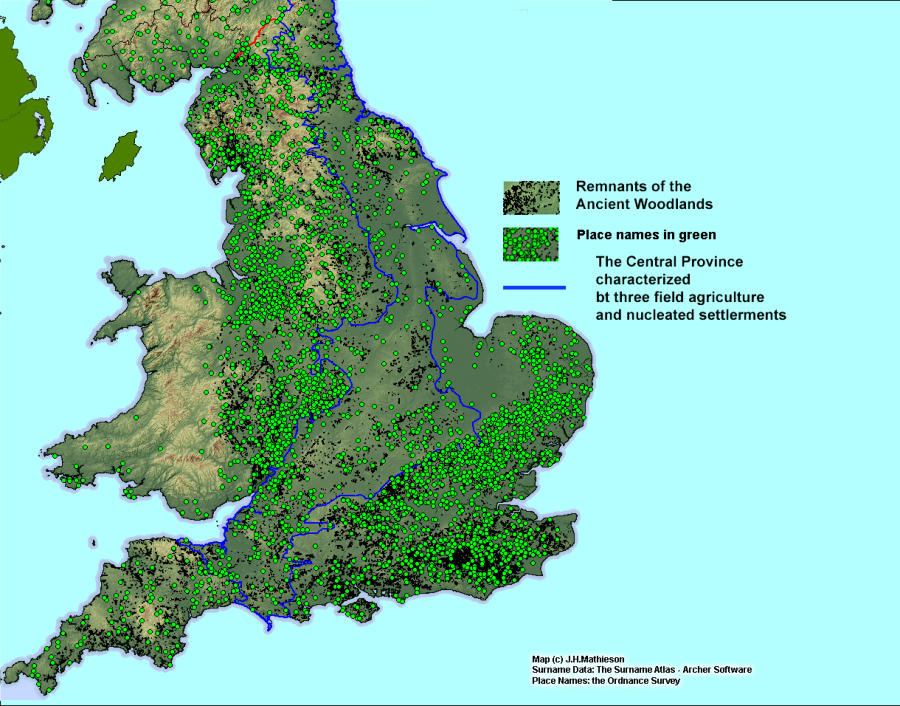
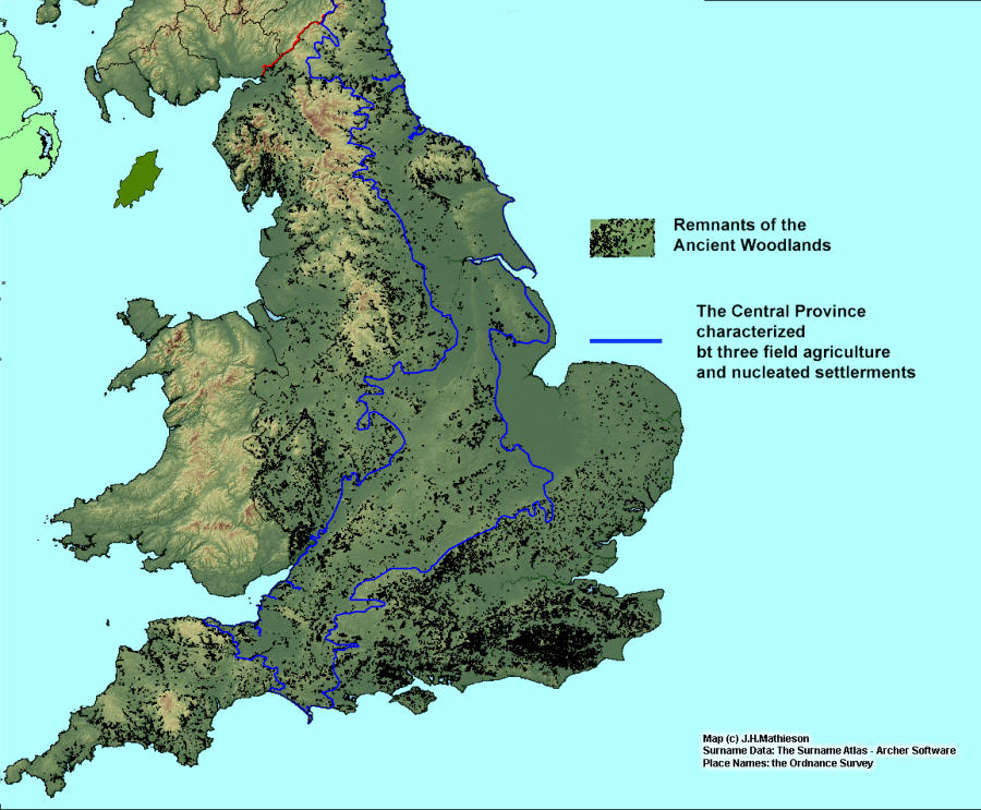
The Regional Landscape
To appreciate why, and most importantly where surnames of the Ancient Woodlands came into
existence, we must examine England’s agricultural landscape and its regional character.
To this end the analysis by Roberts and Wrarthmell in Region and Place, A study of English rural
settlement can assist in explaining the process of woodland surname formation.
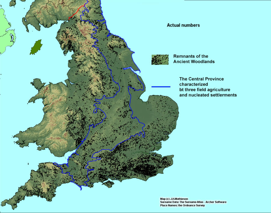
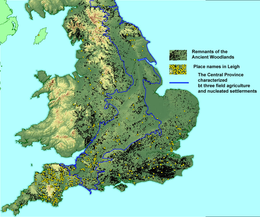
Stretching in a band from the south west through the Midlands to the north east, the great central plain
of England has long been described as a region of "Champion" farming. Being careful not to over
generalize, Roberts and Wrarthmell’s Central Province is characterized as a region in which three field
agriculture and nucleated settlements in the form of manors villages and towns were the dominant form
of spatial organization.
They further divided the landscape into a West and North Region, and an Eastern Region. In these two
areas, flanking the Central Province, the landscape was dominated by closed fields, woodlands,
isolated settlements, hamlets and farms.
The character and extent of the Central Province had largely been cast prior to the time of Domesday
and before the era of large scale surname formation. Extensive woodlands were largely, although not
entirely absent from this region. The peasants and farmers of the region were associated with the
manorial economy, and when they took locative surnames, they would reflect this reality.
By contrast individuals residing outside the central plain had a much wider range of choices when
describing their origins. The density of woods and clearings, and the frequency of independent
settlements, farms and hamlets, provided individuals with a wide range of options by which to identify
themselves or be identified by others.
Surnames from the Woodlands
To examine how closely the distribution of wood land surnames followed the regional scheme provided
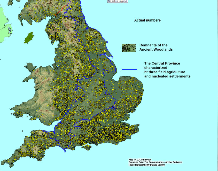
in Region and Place, The Surname Atlas was used to aggregate surnames with woodland suffixes.
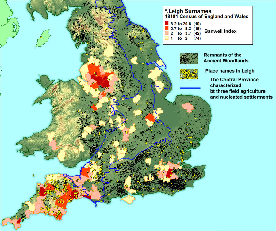
These distributions were mapped using Banwell Indexes with index values greater than or equal to 1. In
other words, where the distribution was higher than the national average. The distributions were then
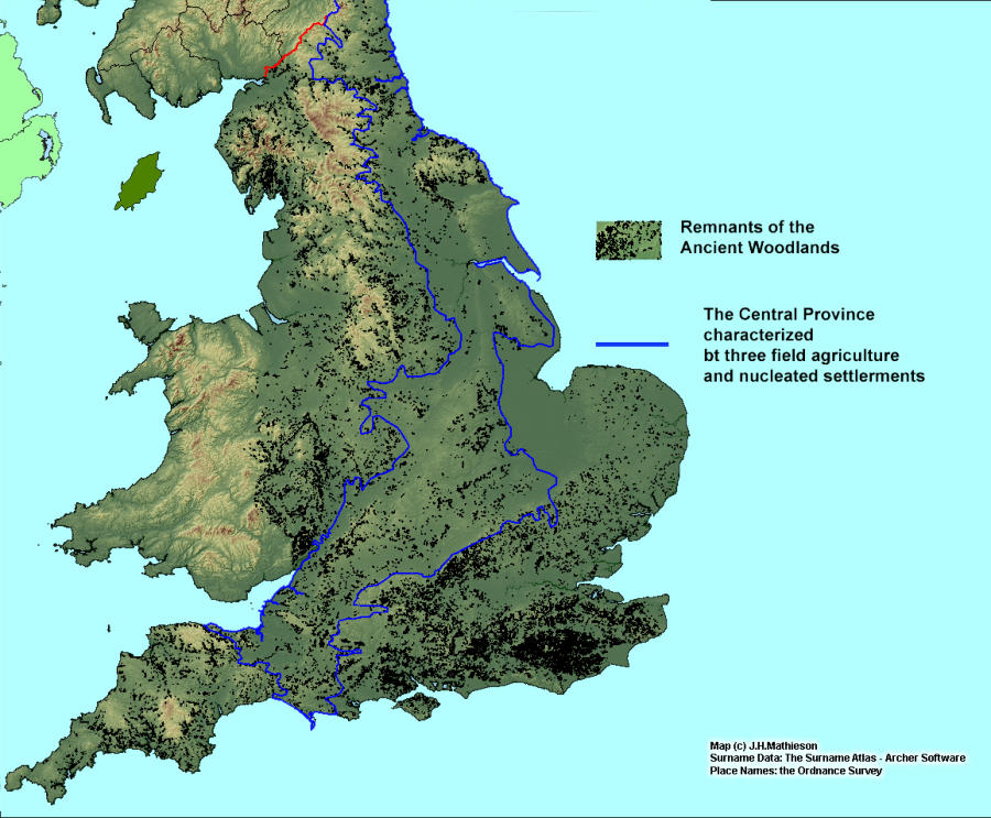
overlain on a base map which included the the boundary of the Central Province, the contemporary
woodlands, and the place names relating to each suffix. The Central Province covers 33% of England’s
land surface. If place names and woodland surnames were uniformly distributed we would expect
roughly the same proportion to be found within the Central Province. The reality is far different.
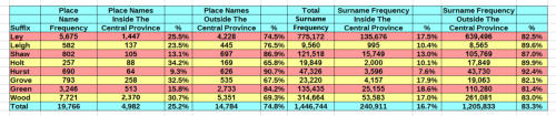
Surname suffixes
The etymology of woodland place names reflects both dialect and function. The first element can take a
variety of forms; personal names, animals, trees and descriptive elements. The following suffixes were
used in the exercise that follows.
•
ley a wood or clearing
•
leigh a wood or clearing
•
shaw from the Old English scaga, sceaga, a copse, grove or small wood
•
holt from the OE holt or wood
•
hurst, hirst, OE hyrst, hillock, knoll copse
•
grove, graf, OE graf a grove or thicket, modern form grave
•
green
•
Wood
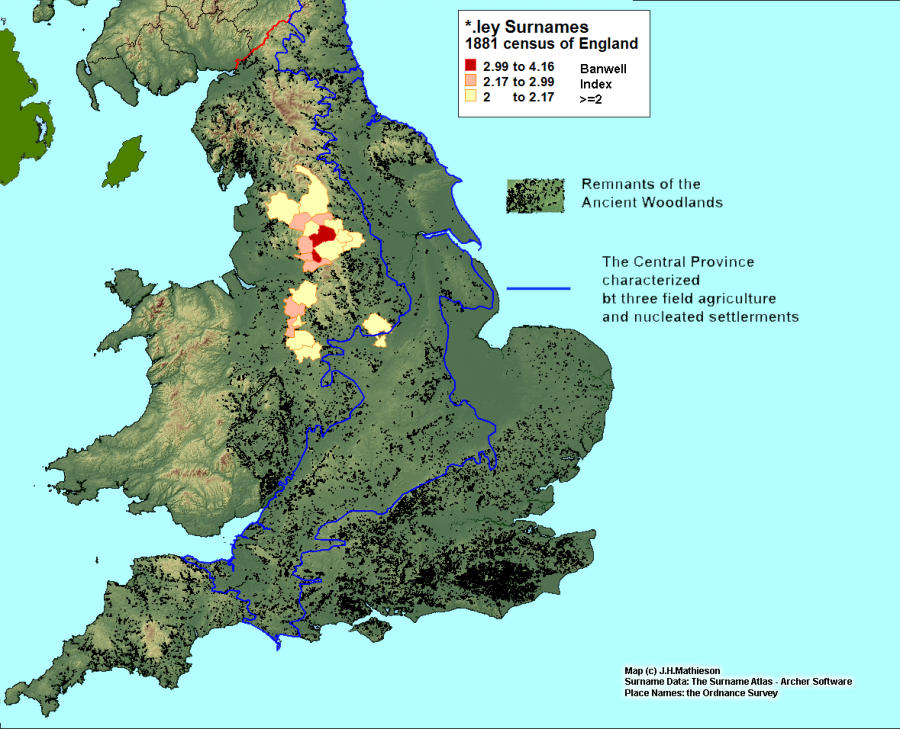
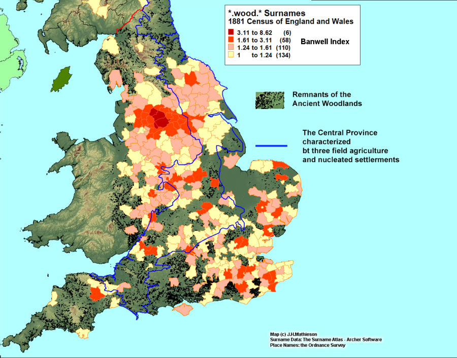
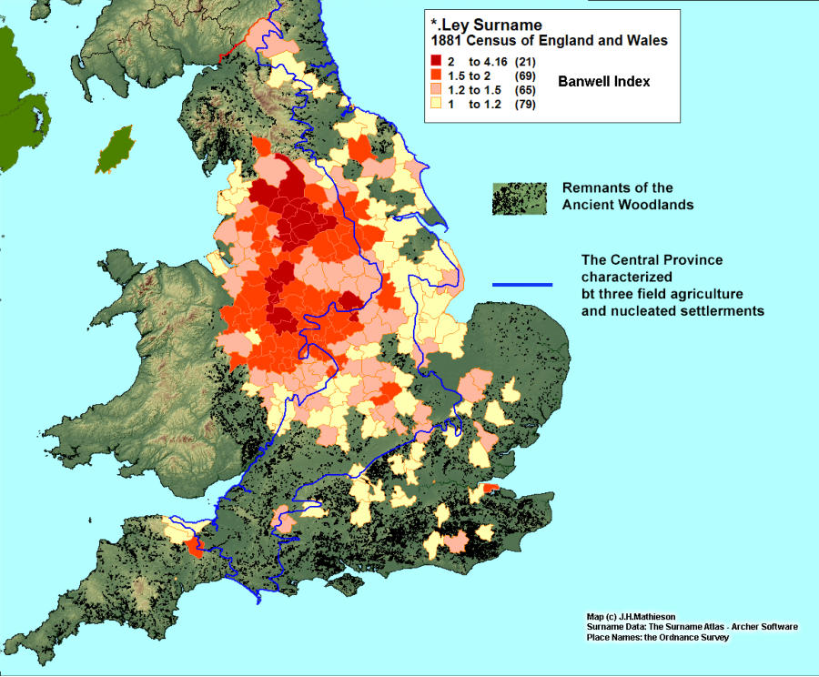
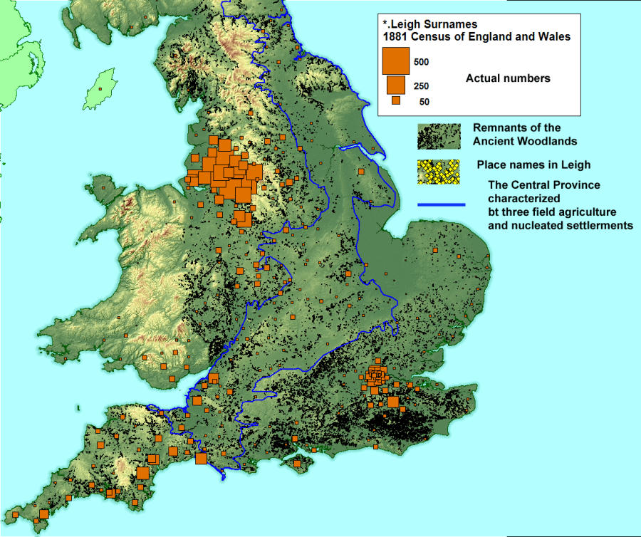
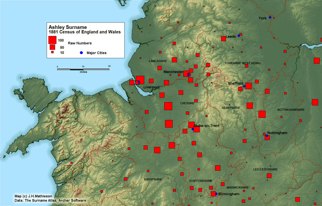
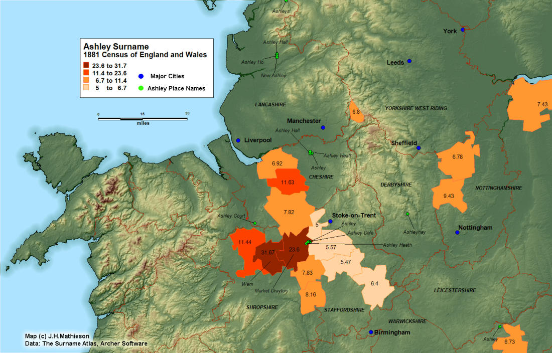
Place names and surnames containing ley - Ley is one of the most common and widespread
woodland place name suffixes. It is of Saxon origin meaning wood or clearing. The place name
frequency in the Ordnance Survey is 5,675 and the surname frequency in the 1881 census was
(775,172). Yet in spite of their high frequencies, neither the surname suffixes or the place names are
uniformly distributed across the English landscape. In fact we find 75% of ley place names and 82.5% of
ley suffixes are found outside the Central Province of England, The highest Banwell Indexes are found
well outside the central plain where values of from 1.5 to 4 times the national average are found on the
Lancashire Plain, Cheshire and the Pennine slopes.
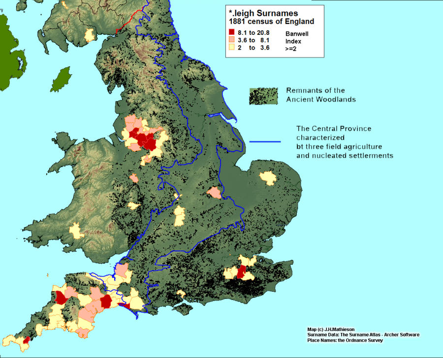
Place names and surnames containing leigh - While the pattern with respect to surnames in
leigh is broadly similar to it’s ley counterpart, there are subtle differences. While the proportion of leigh
place names outside the central provinces is slightly lower at 77%, at the same time the proportion of
surnames found outside the Central Province is dramatically higher at 90%. The distribution also
appears to be bifurcated, with cores in both the Lancashire Lowlands and in Devon and Cornwall. Leigh
place names, are more heavily concentrated in Devon and Cornwall, while the surnames appear to
have ramified more heavily on the Lancashire Plain.
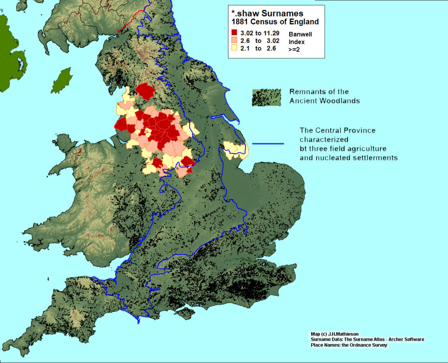
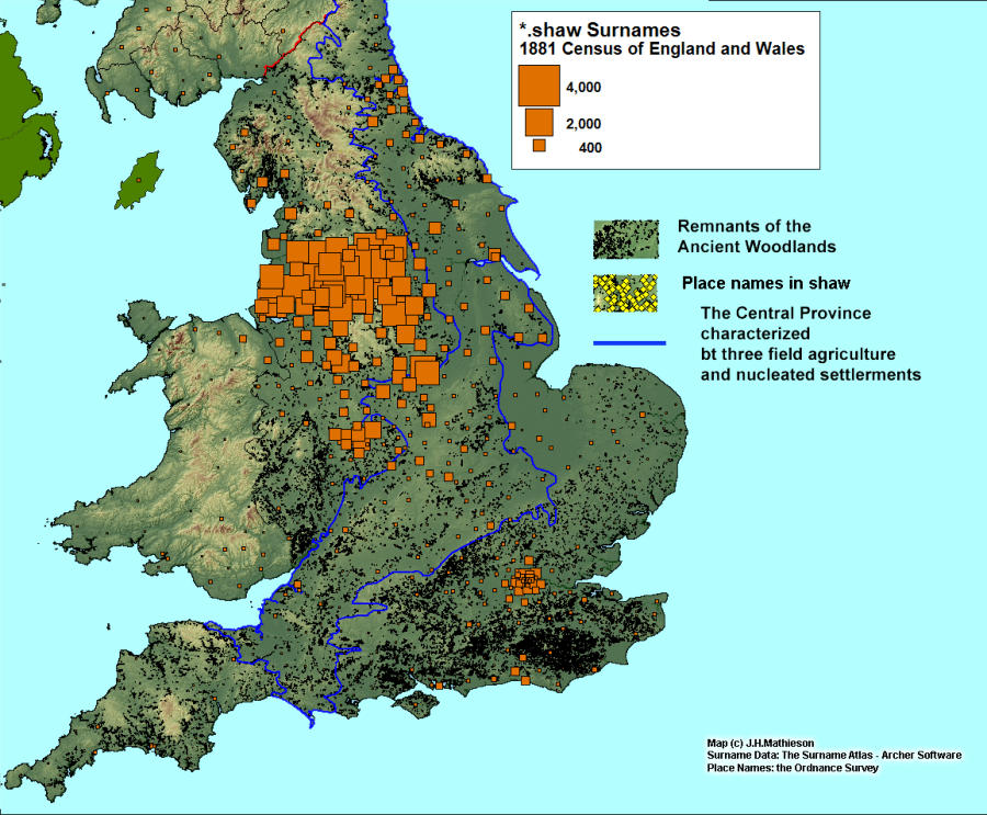
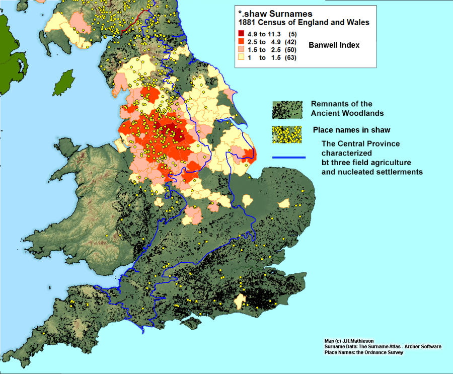
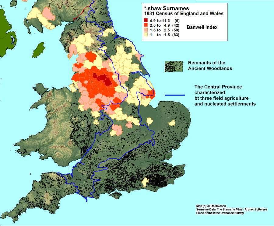
Place names and surnames containing shaw - Scaga, sceaga, a copse, reference a grove or
small wood. Gelling suggests it was a wood of limited extent. She further notes between 16th to the
19th centuries shaw is recorded in the sense of a strip of wood or under-wood forming the bounds of a
field. She believed this meaning was established by the 9th century. Both the place names and
Surnames are highly localizes in the North of England and upland areas of the Scottish Lowlands. 13%
of place names in shaw and 15% of surnames in shaw are found within the Central Province. The
surname Shaw dominates those containing a prefix, with 43% being in the simplex form. The
distribution of the Shaw surname parallels the surnames in shaw so closely one has to suspect that
Shaw is an orphan form of the surnames bearing a suffix.
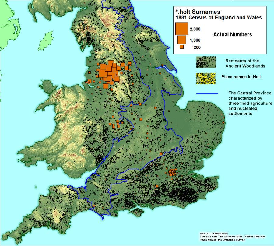
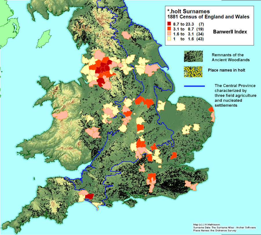
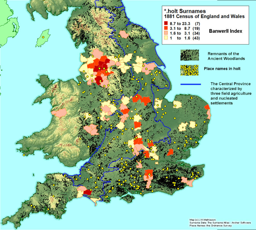
Place names and surnames containing holt -
Gelling interpreted this as a
single species wood or alternatively a small wood, with 32.9% of holt place names are found within the
Central Province. The relatively high percent might be explained by the etymology of the term holt. It
may be that as a “small wood” it might commonly be found within and without the Central Province.
Despite its higher frequency it does not appear to have been the source of many surnames, with only
9.9% of individuals bearing the holt surnames found in the Central Province. The vast majority of
surnames are found in the Lancashire Lowlands.
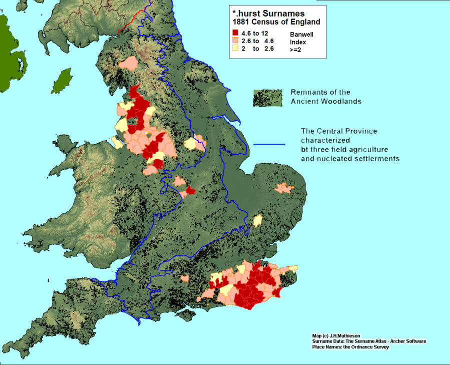
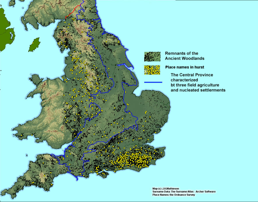
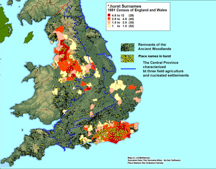
Place
names and surnames containing hurst - Only 9.3% of place names
and 7.6% of surname suffixes in hurst are found within the Central Province. The concentration of place
names is most notable in the county of Sussex, blanketing the area of the Sussex Weald. The
distribution of related surnames is bifurcated between the Lancashire Plain and the south east counties
of Sussex, Surrey and Kent.
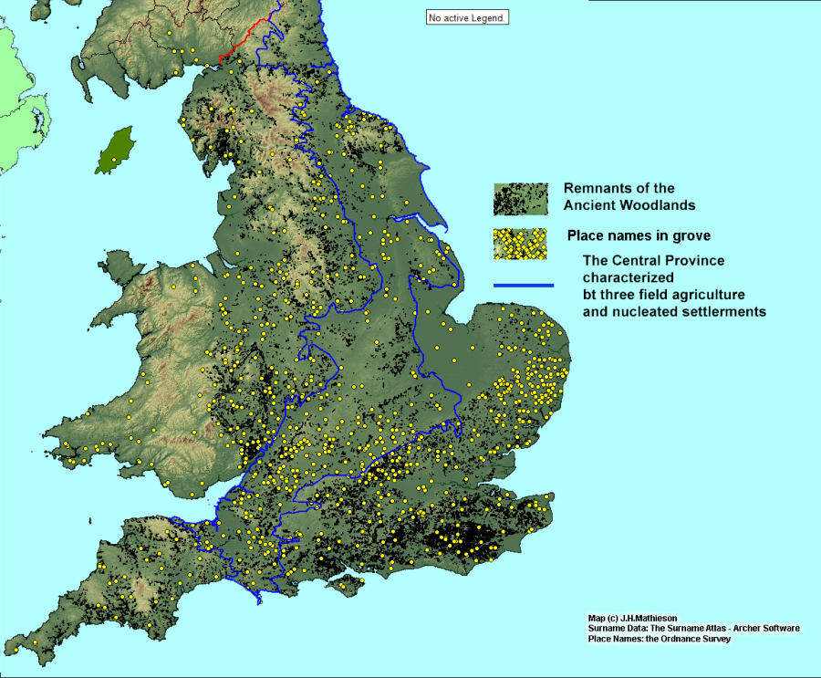
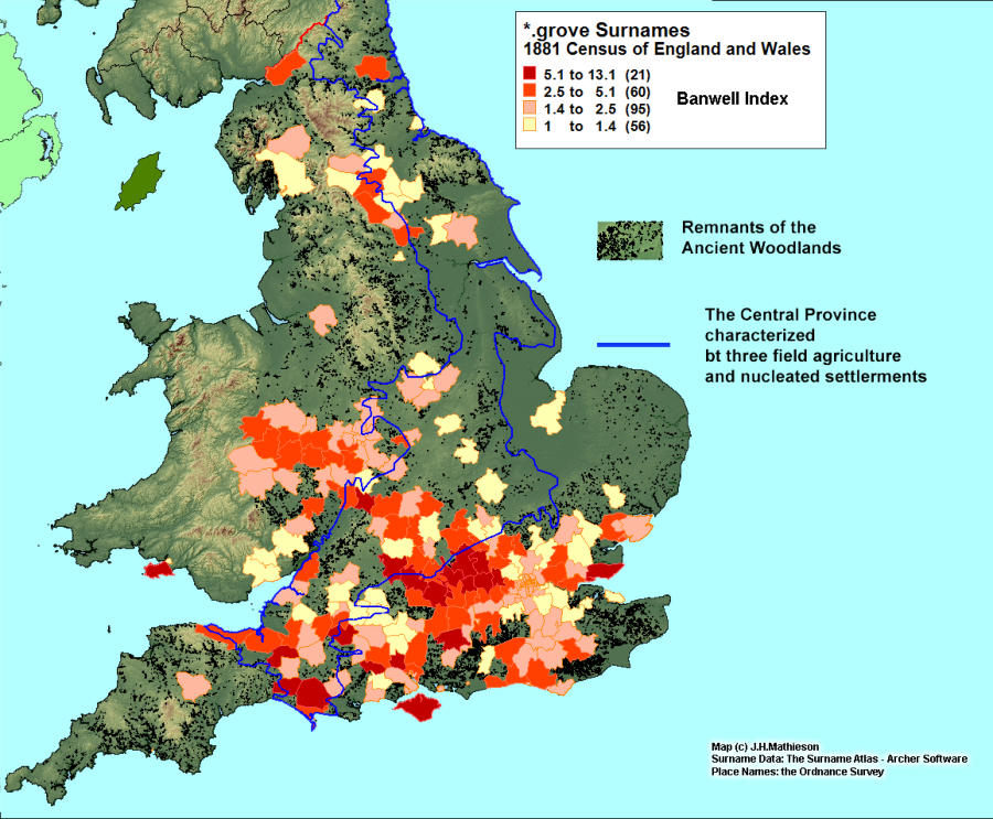
Place names and surnames containing grove - Grove place names are well represented
within the Central Province(32.5%), particularly in south central England. The surname suffixes appear
along the outer margins of the Central Province, notably in Berkshire and Buckinghamshire.
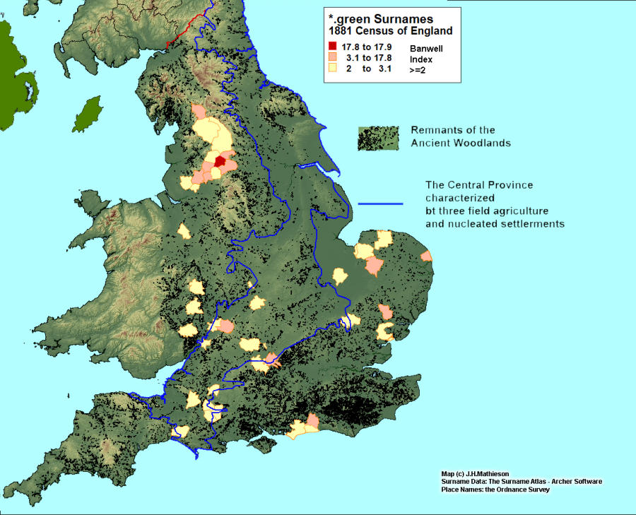
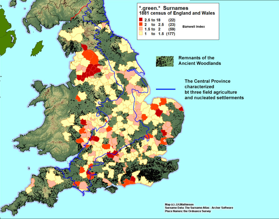
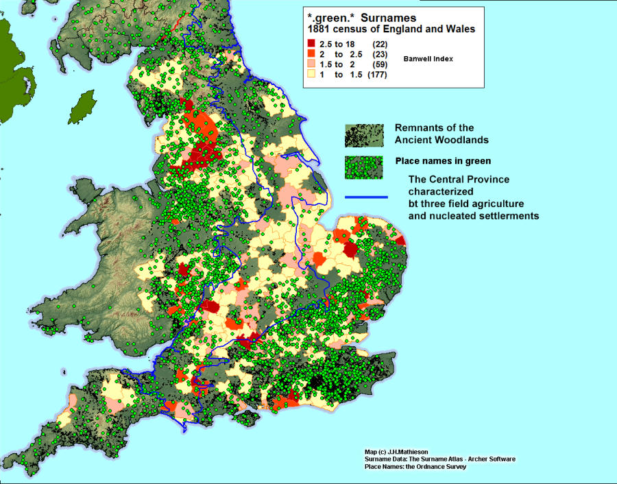
Place names and surnames containing green - the place name element green
can reflect an origin as a clearing from a wood, or as a village green. The distribution of places
containing the green element provides an excellent demarcation of the Central Province with only 15%
of green places found within it’s borders. Those place names that are found within the Central Province
are spatially associated with woodlands. Similarly green surnames suffixes are heavily concentrated
outside the Central Plain, particularly in the Lancashire Lowland and West Midlands. Fully 83% of green
surnames are found outside the Central
Province.
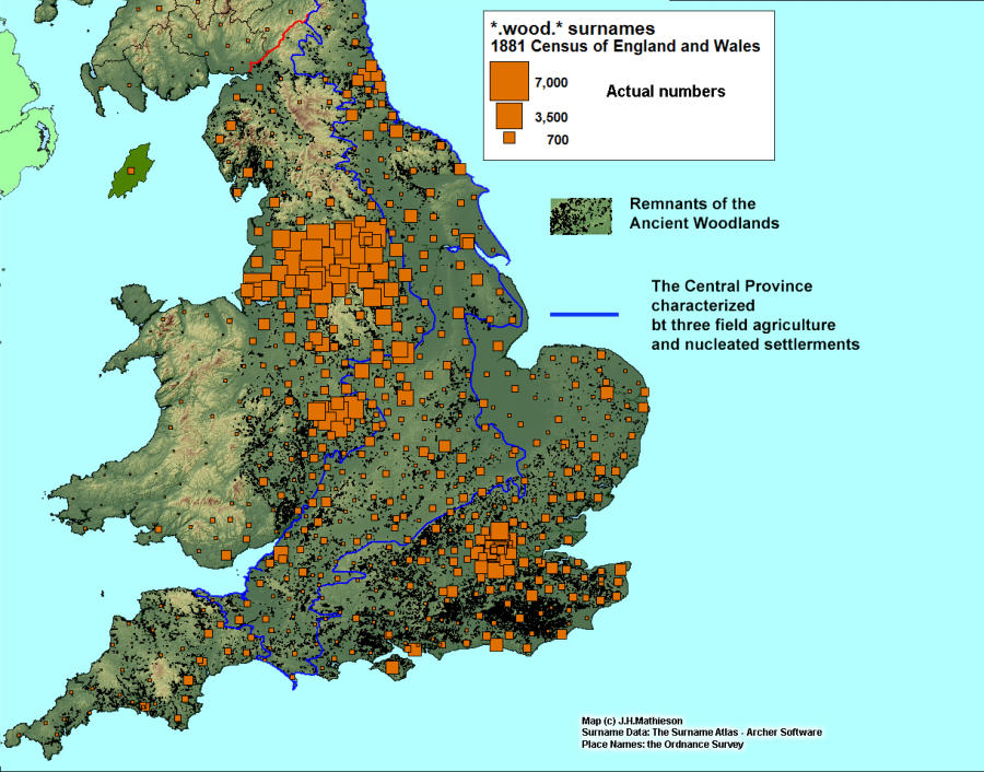
Place names and surnames containing wood - From the OE wudu, later wood, it is an
extremely common place name element. It is often used as a qualifier, (Woodhall, Woodhouse,
Woodkirk), as a descriptive term, Blackwood, Brookwood, and in a possessive form, for example
Archers Wood. As a consequence of it’s widespread use and function, the wood element is found both
within and without the Central Province with 30.7% found within it’s boundary. As would be expected,
surnames associated with the term wood are common, (262 having a frequency of =>50), while their
distribution is still heavily weighted outside the Central Province where the frequency reaches 83%.
Analysis and Conclusion
While both place names and surname suffixes are under-represented in the Central Province, the
imbalance is most evident with the distribution of surname suffixes. Place name frequencies within the
Central Province range from 9.3% to
34.2% with an overall average of
25.2%. By way of contrast woodland
based suffixes average only 16.7%
within the Central Province and
outside the region the average is
above 80%.
In every instance in this exercise the major suffix cores developed outside the Central Province. Over
time as surnames ramify the core will generally intensify while at the same time the distribution will
spread or diffuse within a region reflecting population movement. Two factors may be at play. First the
timing of the adoption of surnames was clearly important. As population expanded in the 12th and 13th
centuries surnames would reflect their local environment. As noted earlier areas outside the Central
Province had a larger range of place names to select from. Many of these places, farms, hamlets and
independent settlements, reflect woodland origins. Secondly as population expanded in the post
Domesday period, more marginal land would come under cultivation at the expense of woodlands,
again providing a source for new woodland names.
Click images to enlarge